1
/
of
1
Tom Harrison Maps
John Muir Trail
John Muir Trail
Regular price
$23.95 USD
Regular price
Sale price
$23.95 USD
Shipping calculated at checkout.
Quantity
Couldn't load pickup availability
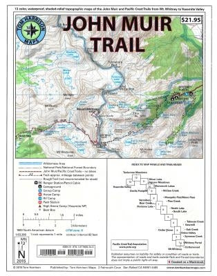
Shaded Relief Topo Maps packet of the famous Sierra High Route that will take hikers from Mount Whitney to Yosemite, CA. Well marked trails over USGS topo maps that were beautifully enhanced with shaded relief to better distinguish details. Scale 1:630360. 1 inch on map equals 1 mile. Whitney Portal, Symmes Creek, Onion Valley, Oak Creek, Taboose Creek, North and South Lakes, Vermilion, Bear Creek, Florence Lake, Pine Creek, Mono Pass, McGee Creek, Devils Postpile, Mammoth Lakes, Agnew Meadows, Silver Lake, Tuolomne Meadows, and finally the Yosemite Valley. GPS Compatible - Complete UTM Grid.
Author: Tom Harrison
Publisher: Tom Harrison Maps
Published: 08/01/2014
Pages: 14
Binding Type: Other
Weight: 0.25lbs
Size: 11.00h x 8.40w x 0.10d
ISBN: 9781877689345
Author: Tom Harrison
Publisher: Tom Harrison Maps
Published: 08/01/2014
Pages: 14
Binding Type: Other
Weight: 0.25lbs
Size: 11.00h x 8.40w x 0.10d
ISBN: 9781877689345
Share